Baroness Hanham maps the progress of government transparency
The national mapping agency is the pioneer in a new era of information transparency by government, Baroness Hanham said today (16 July 2010).
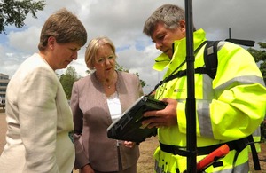
Baroness Hanham on a visit to Ordnance Survey headquarters
Three months after launching the OpenData initiative, Baroness Hanham said Ordnance Survey is leading the race to make public data freely available and accessible.
Free information for all
Since April the government’s mapping agency has provided a range of geographical and mapping information for free, and developed innovative digital tools to help the public sector and businesses use the information.
On a visit to Ordnance Survey headquarters in Southampton, Lady Hanham saw first hand that OpenData is driving efficiency and boosting innovation and entrepreneurship. The free information has already been used to map the famous Elephant Parade across London, and collect road routing information to help the emergency services.
Baroness Hanham said:
“Freeing up this public data has unleashed a wave of fresh thinking by the public sector and businesses. In just three months this new transparency by the government has helped created a stream of fresh applications and websites that are combining free information and digital technology with the good ideas of ordinary people.
“And this is just the start. We’re changing the way government works so more information is available to the public. We’ve already been working with local government to put information on spending, tenders and contracts over £500 online. Local authorities are also publishing job vacancies online for anyone to re-use and re-publish without charge.
“More transparency will lead to greater accountability in government. This will make it easier for local people and communities to get directly involved in issues that matter to them, and demand we work harder to meet their needs.”
Boost for business, art, cycling…
Businesses are already using OpenData to boost their performance. Financial services companies have used the free geographic data to build ‘fraud maps’ that reveal levels of fraud across the country. The maps are revolutionising the way these companies look at fraud because they show trends in different areas. Being able to see where fraud is going up or down helps with risk assessment and supply chain management as well as disaster and contingency planning.
OpenData has also had the domino affect of driving up the use of other free mapping services. The National Archives have started using OS OpenSpace to display a collection of 14,000 inter-war photos.
And Halfords and The Great Tour of Britain have used OpenSpace to launch a unique 64-day cycling challenge circumnavigating the entire coastline of Great Britain. The free service has been used to plot the route for the riders who will raise cash for The Prostate Cancer Charity.
In Cheshire OpenSpace is being used to run a road safety campaign which pulls together a wide range of information including accident hotspots to improve driving skills in the county.